Скачать с ютуб Earthquakes of Indonesia: 2004 - 2019 в хорошем качестве
Earthquakes of Indonesia: 2004 - 2019
4 года назад
Скачать бесплатно Earthquakes of Indonesia: 2004 - 2019 в качестве 4к (2к / 1080p)
У нас вы можете посмотреть бесплатно Earthquakes of Indonesia: 2004 - 2019 или скачать в максимальном доступном качестве, которое было загружено на ютуб. Для скачивания выберите вариант из формы ниже:
Загрузить музыку / рингтон Earthquakes of Indonesia: 2004 - 2019 в формате MP3:
Если кнопки скачивания не
загрузились
НАЖМИТЕ ЗДЕСЬ или обновите страницу
Если возникают проблемы со скачиванием, пожалуйста напишите в поддержку по адресу внизу
страницы.
Спасибо за использование сервиса savevideohd.ru
Earthquakes of Indonesia: 2004 - 2019
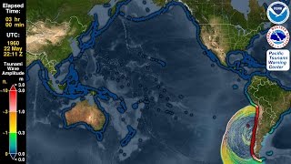
On 26 December 2004 the third-largest earthquake ever recorded struck the coast of Sumatra, Indonesia, with a magnitude of 9.1. It generated the deadliest tsunami in history--and one of the deadliest natural disasters--killing nearly 228,000 people in 14 countries. Indonesia lies above a tectonic plate boundary called a “subduction zone” where the Indo-Australian Plate grinds beneath the Eurasian Plate. Subduction zones can produce megathrust earthquakes with large vertical seafloor motions that cause devastating tsunamis such as the one in 2004. This type of plate boundary can also give rise to volcanoes, and Indonesia is home to many well-known active volcanoes, such as Krakatoa, which can also generate tsunamis with their eruption and collapse. This animation covers the 15 year period since the devastating earthquake and tsunami of 2004. It begins with a map of plate boundaries, showing the complexity of the region, and highlighting the sources of two recent, unusual tsunamis: the Palu Fault that generated a deadly local tsunami from a sideways-moving strike-slip earthquake (and possibly landslides) within a narrow inlet, and the Anak Krakatau volcano (within Krakatoa’s caldera) that collapsed during an eruption to produce another locally devastating tsunami. The animation will then show the earthquakes in sequence as they occur from 2004 through 2009, ending with a summary map showing all of the earthquakes in the animation. Some significant events that occurred during this period include: 26 December 2004 -- M9.1 -- Sumatra-Andaman Islands, source of Indian Ocean tsunami 28 March 2005 -- M8.6 -- Nias–Simeulue (Sumatra), killed more than 900 and caused a small tsunami 27 January 2006 -- M7.6 -- Banda Sea; almost 400 km deep 17 July 2006 -- M7.7 -- Pangandaran (Java); a slow-rupture earthquake with a low shaking intensity that produced a devastating tsunami, approx. 700 dead 12 September 2007 -- M7.9, M8.4, and M7.0 -- Sumatra; 23 dead, small tsunami 3 January 2009 -- M7.7 & M7.4 -- Papua; 4 dead 30 September 2009 -- M7.6 -- Sumatra; more than 1000 dead 6 April 2010 -- M7.8 -- Sumatra; small tsunami 25 October 2010 -- M7.8 -- Mentawai Islands (Sumatra); devastating local tsunami, more than 400 dead 11 April 2012 -- M8.6 & M8.2 -- Indian Ocean; largest strike-slip events ever recorded, small tsunami 2 March 2016 -- M7.8 -- Indian Ocean; strike-slip 28 September 2018 -- M7.5 -- Palu (Sulawesi); strike-slip with locally damaging tsunami, over 4000 dead (mostly from the earthquake) 22 December 2018 -- Anak Krakatau volcanic eruption and collapse causing a submarine landslide and tsunami (no significant earthquake so not visible in the animation); more than 400 dead From 2005 to 2013 the Pacific Tsunami Warning Center (PTWC) provided tsunami warning services to the nations of the Indian Ocean. Today Indonesia, Australia, and India play that role. Indonesia: http://rtsp.bmkg.go.id/ Australia: http://www.bom.gov.au/tsunami/ India: https://incois.gov.in/tsunami/eqevent... ----- To see an animation of the 2004 Indian Ocean tsunami, please watch: • Tsunami Forecast Model Animation: Sum... To see a comparison of the relative sizes of some historic earthquakes, please watch: • Perspective: a graphical comparison o... To see how subduction zones make tsunamis, please watch: • How to Make a Tsunami ----- Earthquake Data Source: United States Geological Survey (USGS)/National Earthquake Information Center (NEIC) searchable catalog: https://earthquake.usgs.gov/earthquak... Plate boundaries from UTIG’s PLATES project: https://ig.utexas.edu/marine-and-tect...
Comments