Скачать с ютуб Agricultural Mapping with Drones and Satellites в хорошем качестве
Agricultural Mapping with Drones and Satellites
3 года назад
Из-за периодической блокировки нашего сайта РКН сервисами, просим воспользоваться резервным адресом:
Загрузить через ClipSave.ruСкачать бесплатно Agricultural Mapping with Drones and Satellites в качестве 4к (2к / 1080p)
У нас вы можете посмотреть бесплатно Agricultural Mapping with Drones and Satellites или скачать в максимальном доступном качестве, которое было загружено на ютуб. Для скачивания выберите вариант из формы ниже:
Загрузить музыку / рингтон Agricultural Mapping with Drones and Satellites в формате MP3:
Если кнопки скачивания не
загрузились
НАЖМИТЕ ЗДЕСЬ или обновите страницу
Если возникают проблемы со скачиванием, пожалуйста напишите в поддержку по адресу внизу
страницы.
Спасибо за использование сервиса savevideohd.ru
Agricultural Mapping with Drones and Satellites
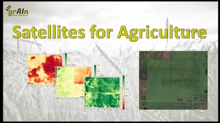
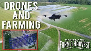
KBFA Advisor Andrew Bennett describes how he uses one of the least expensive drones available and free software to make base maps and 3-D topographic maps. He also shows where to get free satellite data to map the productivity of any farm's vegetation through the seasons. 00:00 - Intro 01:15 - Mavic Mini 2 02:58 - Basic Maps 04:41 - Map Quality 06:05 - Autopilot 07:14 - Licensing 08:01 - Big Farms 08:50 - LIDAR 09:52 - Satellites 10:13 - Productivity Maps 11:14 - NIR Drones 13:10 - Light Waves 14:32 - Plant Reflectance 17:02 - Satellite Data 18:46 - FBN 21:09 - Earth Explorer 24:20 - QGIS This video is part of the " Agricultural Drones" series hosted by Kootenay & Boundary Farm Advisors on March 18, 2021. Separate videos and transcripts for each of the following presentations are available at www.kbfa.ca: Introduction to the Agricultural Drones" series • Introduction to "Agricultural Drones"... Latest Ranching Drone Research with Dr. John Church (Thomson Rivers University, Associate Professor) • Latest Ranching Drone Research with D... Big Rig Spraying Drones and Nanotechnology with Chris Noske (Pro Ag, president) • Big Rig Spraying Drones and Nanotechn... Drones for Farm Record Keeping with Tony Jeske • Drones for Farm Record Keeping with T... Ranch Mapping through the Seasons with Devin Chursinoff (maps made by Jon Wilson of 4 Elements Emergency Consulting, Grand Forks BC) • Ranch Mapping through the Seasons wit...
Comments